


DJI Matrice 4E Surveying Bundle
- The Ultimate Surveying Bundle for the DJI Matrice 4E
- Emlid RS3, Survey Pole
- 5 x Ground Control Points
- 1 Year RTK Unlimited Subscription,
SKU: DJI-Matrice-4E-Surveying-Bundle
Material Code: DJIEMAT4ENUK1Y
Brand: DJI
Included with the DJI Matrice 4E Surveying Bundle
Over £2110.00 worth of extras included with the DJI Matrice 4E Surveying Bundle!
-
 DJI Terra Pro 1 Year (1 device) RRP: £1,600.00
 -
 Drone Safe Register Professional - 1 Year RRP: £238.79
 -
 RTK Network Subscription Unlimited 30 Days RRP: £180.00
 -
 A2CofC Online Training Course RRP: £100.00
Next Working Day Delivery
In Stock : Order within 01 hrs 17 mins for delivery by Wednesday, 29th April (UK Mainland)

Safe & Secure Checkout
DJI Matrice 4E Surveying Bundle
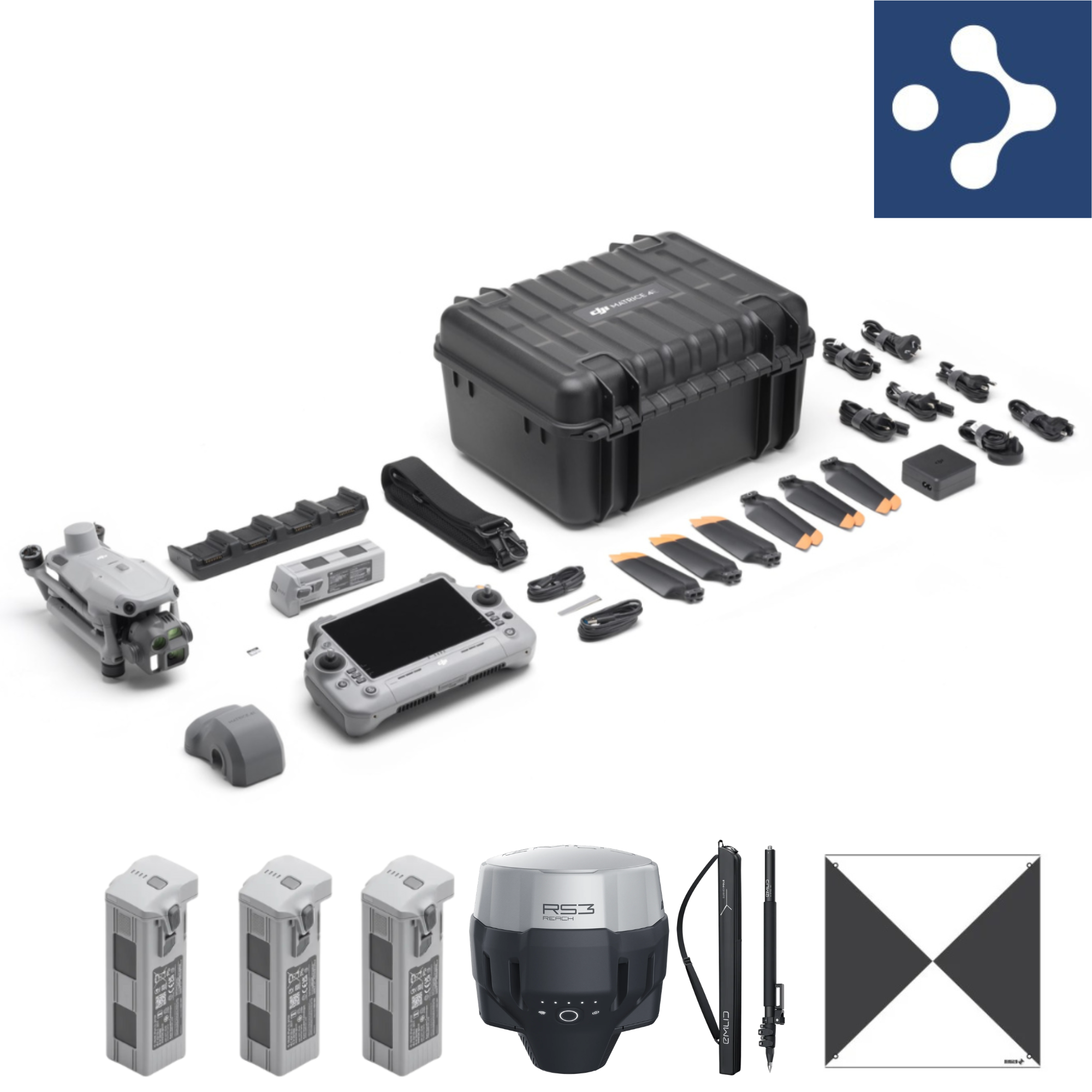
The DJI Matrice 4E Surveying Bundle is a complete, high-precision aerial mapping solution designed for professionals who demand accuracy, efficiency, and reliability in the field. Built around the powerful Matrice 4E drone platform, this bundle provides everything needed to carry out advanced surveying, mapping, and geospatial data collection workflows.
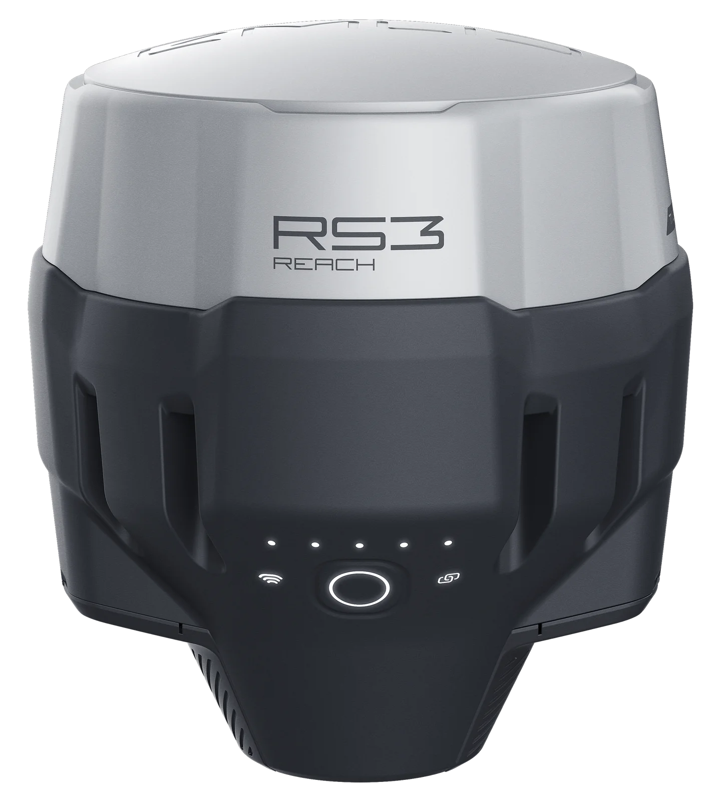
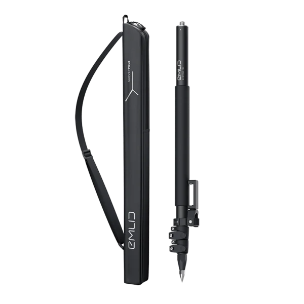
At the core of the package is the Emlid RS3 RTK Receiver, delivering centimetre-level positioning accuracy for precise ground measurements. This is complemented by five durable ground control points (GCPs), ensuring consistent and verifiable georeferencing across survey sites. The included Emlid Survey Pole offers a robust and ergonomic solution for accurate point collection in the field.
To further enhance accuracy and workflow efficiency, the bundle includes a one-year Unlimited RTK Network Subscription with Premium Positioning. This provides access to high-quality correction data, reducing setup time and eliminating the need for a local base station in many scenarios.
Together, these components create a seamless end-to-end surveying system, ideal for applications such as land surveying, construction site mapping, infrastructure inspection, and environmental monitoring. The DJI Matrice 4E Surveying Bundle empowers professionals to capture reliable, survey-grade data with speed and confidence.
1 x DJI Matrice 4E
4 x DJI Matrice 4 Series Battery
1 x DJI RC Plus 2 Enterprise
1 x DJI 100W USB-C Power Adapter
1 x DJI Matrice 4 Series Charging Hub
1 x microSD Card
1 x DJI Matrice 4E Gimbal Protector
1 x DJI Cellular Dongle 2 Pry Bar
3 x DJI Matrice 4 Series Propellers
1 x 100W Power Adaptor AC Cable
1 x USB-C to USB-C Data Cable
1 x USB-A to USB-C Data Cable
1 x DJI Matrice 4 Series Storage Case
1 x DJI Matrice 4 Series Storage Case Shoulder Strap
1 x Emlid RS 3 RTK Reciever
1 x Emlid Survey Pole
Emlid RS3 RTK Receiver vs DJI D-RTK 3 Multifunction Station
| Feature | Emlid Reach RS3 RTK Receiver | DJI D-RTK 3 Multifunction Station |
|---|---|---|
| Primary Role | Ground surveying (rover/base) | Drone RTK base station & relay |
| Main Purpose | Capture precise ground control points and survey data | Provide real-time RTK corrections to drone |
| Accuracy Focus | Survey-grade ground truthing | Real-time aerial positioning |
| RTK Accuracy | Centimetre-level positioning | Centimetre-level positioning (RTK fixed) |
| Typical Use | GCPs, checkpoints, topographic surveys | Drone flights, mapping missions, signal relay |
| Mobility | Portable, pole-mounted rover | Typically static (base or relay setup) |
| Workflow Type | Pre/post-flight ground survey | Real-time in-flight correction |
| Ecosystem | Open (supports NTRIP, PPK, multiple software platforms) | Integrated within DJI ecosystem |
| Connectivity | NTRIP, radio, data logging | OcuSync transmission + RTK corrections |
| Additional Features | Post-processing (PPK), flexible survey workflows | Can act as signal relay to extend drone range |
DJI Matrice 4E + Emlid RS3 vs DJI Matrice 4E + DJI D-RTK 3
| Feature / Decision Factor | DJI Matrice 4E + Emlid RS3 RTK Receiver | DJI Matrice 4E + DJI D-RTK 3 Multifunction Station |
|---|---|---|
| Core Strength | Highest possible survey accuracy | Simplified RTK drone workflow |
| Primary Use Case | Survey-grade mapping with GCPs and validation | Fast, efficient RTK drone mapping |
| Accuracy Approach | Ground control points + independent GNSS verification | Real-time RTK corrections to drone |
| Data Confidence | Very high (independent ground truthing) | High (but relies on drone RTK solution) |
| Workflow Type | Traditional surveying workflow (GCP-based) | RTK-enabled aerial workflow (reduced need for GCPs) |
| Setup Time | Slower (requires GCP placement and survey) | Faster (minimal ground setup required) |
| Ease of Use | More technical (surveying knowledge required) | Easier for drone operators |
| Flexibility | Works with any drone, GNSS system, or workflow | Primarily designed for DJI ecosystem |
| Post-Processing | Ideal for high-accuracy outputs and validation | Faster processing, fewer inputs required |
| Best For | Surveyors, engineers, construction professionals needing verifiable data | Drone operators, mapping companies, rapid deployment projects |
Submit Your Review
Your email address will not be published. Required fields are marked *
After first positive buying experience, I come back for another drone. Same like first time was the best price on the market plus various gifts included. Before buying i...

Ordered a dji mini 5 pro at half 3 and at 8.20 the next day I had it great turn around everything packaged well will use them again for shore

Great price, great service. Thank you. I Fully recommend this company.

Great service from Drone safe store again. Fair price and very fast delivery. Thanks.

OMG!. Wow!. I'm so very happy that I have a new MAXX radio car control n it's my new hobby. I really appreciate it. I've used few times n it's absolutely brilliant.. Than...

I visited this store yesterday for the first time with the intention of finding out which drone was suitable for me and my needs, and was not disappointed. Tom had plenty...

At last found a suitable bag for a Mini 4 pro drone, that fits everything securely.
